150 Years of Change: How Old Photos, Recaptured, Reveal a Shifting Climate
- Science
- March 5, 2025
- No Comment
- 97
For 30 miles we bounce along a dirt road in southwestern Wyoming, heading toward a jagged skyline. It’s early September and the aspens are starting to turn yellow. As we climb toward the mountains, the air grows colder. Soon the road will see snowfall.
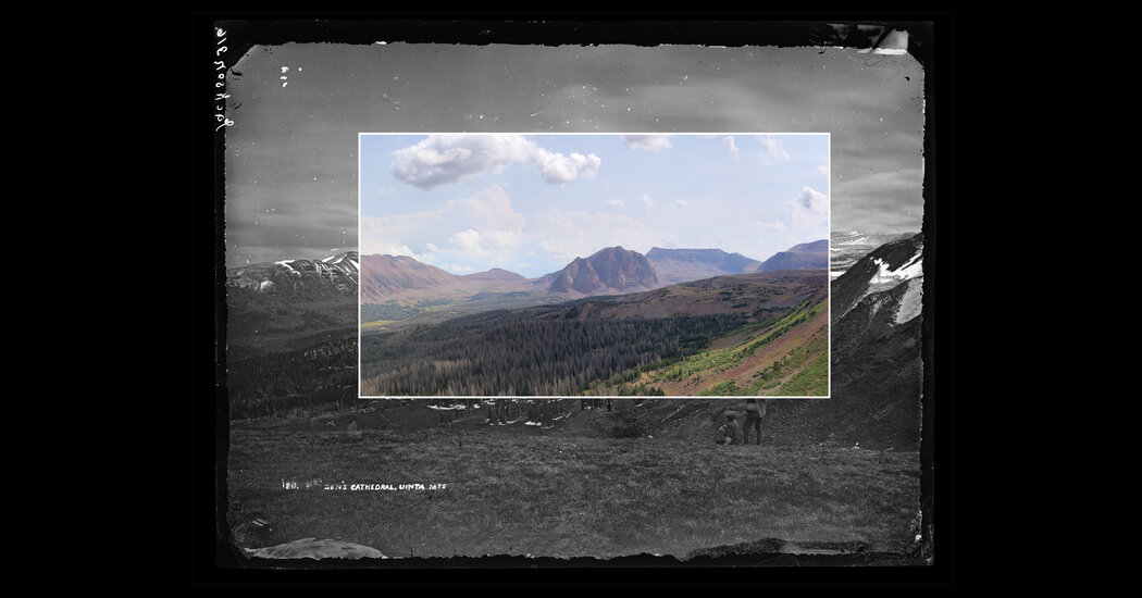
Jeff Munroe, a professor of geology at Middlebury College in Vermont, is taking us back in time. Our small group of scientists and adventurers will be backpacking into the Uinta Mountains to recreate a series of photographs made in 1870 by William Henry Jackson, a photographer who worked for the United States Geological Survey under the direction of the geologist Ferdinand Vandeveer Hayden. Jackson and Hayden documented the landscape and natural resources of the Wyoming Territory in support of U.S. expansion. We’re going to see exactly how the environment has changed.
Re-photography — capturing the same scene from the same location after a span of time — enables scientists to track long-term changes such as alpine tree-line rise, shoreline erosion and glacial retreat, which are difficult to study otherwise. The technique can be more challenging than it sounds. Finding the general location is the first hurdle, as place names change over time and descriptions are separated from historical images. Next, researchers must identify the precise coordinates of the original tripod placement, which can be especially vexing in landscapes prone to rockslides or erosion. Subtle variations in photographic equipment can also make it hard to create matching images as cameras, films and lens sizes change.
In our case, the difficult terrain, which was now coupled with unsettled weather, meant that we might not even be able to reach the general area, let alone find half a dozen tripod locations. And although some re-photography projects rely on drones to scout their locations, we’ll be doing all our work on foot, as Jackson had.
Jeff first rephotographed these Uinta sites in 2001. What he saw then would have been unimaginable in the 19th century. Elements of the landscape that Hayden described as everlasting, from the “perpetual snows” to the “upper limit” of the tree line, were changing. Over the intervening 131 years, the climate had warmed. Ecological changes were plainly visible in Jeff’s new photographs. Trees had filled in the open meadows and ascended the mountain slopes. Lower-altitude species had established themselves higher up. All this change was squeezing the unique high alpine areas and the species that have adapted to them. Soon they would have nowhere left to go.
When I asked Jeff, before our trip, about why he planned to rephotograph these sites again just 23 years later, he explained that the pace of climate-driven changes is accelerating. “If I had looked at this landscape between 1950 and 1975, it might have changed a little bit,” he said. “But I think between 2001 and 2024, it’s going to have changed a lot more, in roughly the same amount of time.”
Working from Jackson’s photographs allows Jeff and his collaborator, Townsend Peterson, a professor of ecology and evolutionary biology at the University of Kansas, to see more than 150 years of change, overlaid on top of the hundreds of millions of years buried in the landscape.
*
AFTER AN HOUR on the road, we cross the Utah state line. Jeff predicts we’ll have solitude here in the Uintas. As it turned out, we’d see only three other people during our entire trip.
We pull into the parking lot. On the tailgate of Jeff’s rented truck, two graduate students from the University of Kansas, Joanna Corimanya and Anahí Quezada, wrestle with their heavy backpacks. In addition to their backpacking gear, they’re carrying cameras and GPS equipment to record the views for later analysis back in Peterson’s lab. We’re also joined by Eric Glassco, a former Army Green Beret who began exploring and photographing in the Uintas when he retired from the Special Forces.
A few minutes into our hike, a hard rain starts, unlocking the scents of the forest. While we zip up our rain gear, Eric tells us that a week ago his tent had been shredded in the Uintas by “peanut-size” hail. This is a place of extremes. The east-west-oriented range boasts a vast area of uninterrupted high-elevation terrain, including at least 19 summits over 13,000 feet. Temperature swings and storms come on suddenly, and the landscape offers few options for cover.
We climb a series of steep switchbacks and eventually pass through a trough of reddish cobbles. This, Jeff explains, is the lateral moraine, the debris that the ancient glacier picked up and deposited at its edge. We continue climbing and enter the High Uintas Wilderness, managed by the Wasatch-Cache and Ashley National Forests. Above this point, no mechanized equipment or motor vehicles are allowed.
At around 11,000 feet, our group reaches a broad plateau of short tawny grasses. Dotted with intermittent clusters of stunted, shrubby trees, this is the beginning of the tree line, above which trees are unable to grow. We gather under a tarp to boil water for our dinners. Lightning rips through the woods. I look around nervously, but Jeff is calm; he guesses it struck a quarter-mile away.
Storms pass through our campsite several more times overnight. I wake to find my tent looking like limp laundry on a clothesline, but inside I’m still dry and warm.
*
AFTER BREAKFAST, we pack up and make our way back to the trail where dark-eyed juncos are singing from the bushes. Jeff thinks the Hayden party may have passed through here just a few days later than us in September of 1870. From here we can see down to Bald Lake, the site of our next camp. Beyond, the classic skyline view of the Uintas starts to reveal itself, featuring Gunsight Pass and Kings Peak, the highest point in Utah at 13,528 feet.
Thick clouds are building again, so we quickly descend, filter the lake’s cold water and set up camp, then head out to scout our first photo point, Bald Lake. Jackson’s photograph shows three men seated in the open foreground, wearing hats and woolen jackets. It’s hard to make the view match the printed photo that Joanna and Anahí brought along. The grassy ground where Jackson’s colleagues posed is now a thicket of trees.
After we finish the Bald Lake photograph, we cross the tundra, heading toward the Red Castle, a mountain that Hayden’s party described as a great “Gothic church” of purplish rock. The view is like nothing I’ve seen before. I’m surprised even by the description of it as “tundra,” a term I’ve only ever heard applied to Arctic regions. We’re still trying to find the first tripod location when a frigid wind gushes across the plain, splattering our jackets with wet snow.
*
ON OUR LAST FULL DAY in the mountains, we set out in search of two more photo points. Jeff’s saved GPS locations lead us off-trail across the plateau, then down a slope. Near the border of a tree-line forest, we pass several small lodgepole pines. “We’re descending into the vanguard, Jeff says, referring to the trees. “They’re like a rising wave.”
Jackson noted in 1870 that his photographs were taken at “the upper limit of arborescent vegetation.” Now, lodgepole pines, which typically aren’t found this high up in the Uintas, are settling in above the old tree line. The expanded range of a species like this points to the changes associated with a warming climate, including higher nighttime temperatures and fewer days of deep freeze.
Jeff is deep in memory, following a mental map, since the GPS location isn’t quite right. I offer to show him a copy of the image on my phone, but he doesn’t need it.
Joanna and Anahí take a few photos, knowing at least that we have a skyline match. Back in the lab with Peterson, they’ll layer the photographs, locking the images into place with known GPS coordinates. Joanna describes the process as “pulling a string” through the layers. The composite will allow them to measure the height of the tree line and the density of the forest in comparison with historical images.
Jeff keeps pacing around, looking for a better window into the past. When he spots a familiar tree, the rest of the view settles into place. There’s the flat rock at the edge of the precipice; here’s the low tangle of trees, though grown much larger. I back up, look down and notice a pile of rocks. Jeff remembered building a cairn to mark this place 23 years ago.
Jeff wonders aloud, “Were you even alive when I made this cairn?” Anahí had been 4 years old, living in Ecuador. Eric joined the Special Forces that year. I was in college, studying in France. It’s a world away for all of us. And yet here we are together now, watching this ancient landscape transforming at a rate that’s visible even in human terms.
*
HAYDEN, THE GEOLOGIST in charge of the 1870 expedition, detailed the region’s abundant natural resources in the formal report that was published upon his return to Washington, D.C. He promised “millions of feet of timber” for the railroad, as well as pasture lands and plentiful water that could be used to irrigate crops. His mandate was to make this place widely known and accessible, in scientific, economic and cultural terms. The Hayden party was the vanguard, the rising tide of their day. Their work facilitated enormous impacts, including white settlement and the violent displacement of Indigenous people, expansion of the railroad, grazing, farming and mining. All of these changes are related to the long-term effects that we’re seeing now — the warming climate and the advance of trees into the alpine zone.
But the historical photographs are also valuable. “Scientists can be so excited about their data, but they’ve got caveats and footnotes and ambiguities,” Jeff told me. For nonspecialists, he says, data can be tricky in a way that photography isn’t. Photo pairs, he explains, can tell a story — “about how humans have been changing the climate, changing the landscape, changing ecosystems for a long time, and dealing with the consequences.”
A couple of weeks later, Joanna, Anahí, Townsend Peterson and I met on Zoom to discuss their preliminary results. At Bald Lake, one of the tree lines had been extremely stable, rising less than three and a half feet between 1870 and 2001. But since 2001, that same tree line has climbed a staggering 213 feet. Tree-line advance varies across different sites because of factors including slope, sun exposure and soil quality; not every location experienced such dramatic increases. Still, the group found that tree lines in the Uintas are rising overall.
At a site near Red Castle, only about 260 vertical feet of tundra remain above the tree line, which had advanced at a rate of nearly five feet per year between 2001 and 2024. The loss of the tundra would mean the disappearance of species like marmots, ptarmigan and rosy finches, all of which live in this distinctive environment.
Peterson clarifies that his group isn’t designing the conservation solutions. “What we’re doing is raising the red flag,” he says. They aim to use re-photography to identify sites experiencing rapid change, in the Uintas and around the world.
Standing on the tundra with Jackson’s photographs in hand felt like squinting into the past. As we compared then and now, the dark clouds of the future seemed to gather on the horizon.
Kim Beil’s previous work for The Times includes an essay about an enigmatic Ansel Adams photograph and a roundup of historic observatories around the United States.
Follow New York Times Travel on Instagram and sign up for our Travel Dispatch newsletter to get expert tips on traveling smarter and inspiration for your next vacation. Dreaming up a future getaway or just armchair traveling? Check out our 52 Places to Go in 2025.
#Years #Change #Photos #Recaptured #Reveal #Shifting #Climate